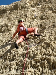
 Look that rock ! Quite unique, a very hard limestone. It looks like just coming out of the sea!
AY & AÏN JEDDAH – KERAK REGION
Approach/access 1 : from the North, and from Kerak.
From Kerak castle (km 0) drive the streets down on the East side of the hill. The road goes around the south end of the castle basement.
– Drive down to Al Shabhia (km 3) on the West side valley.
– At 3,5 km, in Al Shabhia, junction to the left for Ay et Kathrabba (crossing that village is a bit of confusing…)
– At 13,2 km. in the village of Ay, take a right hairpin-like turn at the level of a greenish metal bus-stop shelter (minimarket at the corner).
– At 14 km pass under the power line. Keep driving down, and take a right at km 14,5 (dirtroad at the start). Pass again under the power line.
– At 15,1 km take to the left (ruines).
Arrival at the bottom of the crag, at km 16 from Kerak (Djouma el Bdoul sector) after following the top of the crag, which is clearly visible whilst driving.
Altitude : 715 m.
GPS : 36R 0751251 / UTM 3448741
Park left or right of the road, after a steep winding section around the southern end of the crag, in the wadi bed.
DO NOT HINDER THE ACCESS TO THE FIELDS !
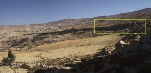 Location of Djouma el B’doul sector on Ay-Kathraba crags
Approach/access 2 : from the South, from Tafileh and Al Mazar
Reach Al Mazar (12 km south of Kerak).
– From the crossed downtown, turn on the left (W), in the direction of Ay-Kathrabba-Taybah, just after the main roundabout, at the level of a police kiosk. Km 0.
– Do not leave the main road untill Kathrabba, first encountered village.
Turn below to the right on the first crossing (9,6 km.) and drive to Ay, characterized by the blue dome of his great mosque (11,5 km.).
– Km 12,4. greenish metal bus-stop shelter on the left at a street junction. Take the left (minimarket at the corner).
– At 13 km pass under the power line. Keep driving down, and take a right at km 13,7 (dirtroad at the start). Pass gain under the power line.
– 14,3 km take to the left (ruines).
– Arrival at the bottom of the crag (Djouma el Bdoul sector), at km 15,2 from Al Mazar (27 km from Kerak, via Mazar), after following the top of the crag, clearly visible whilst driving.
Altitude: 715 m.
GPS: 36R 0751251 / UTM 3448741
Park left or right of the road, after a steep winding section around the southern end of the crag, in the wadi bed.
Hight: 15 to 20 meters, for an overall lenght of nearly 1 km., but with only 3 sectors of good rock.
Orientation WNW. Shade in the morning. Can be windy.
Solid and steep limestone for the climbing sectors. Some other parts should be avoided because of the very bad rock quality …
Three possible sectors.
The first-one encountered is the most developed – it’s called Djouma el B’Doul. 5 to 6 bolted lines, from 5c/6a to 6b/c.
Style: steep compact walls, well carved rock. Vertical slabs and steep cracks.
* Spacious bottom (good with children). Caves, orchards and fields…
In situ equipment: 10 mm bolts.
Material: 10 quickdraws max.
Food-water: Ay et Kathrabba
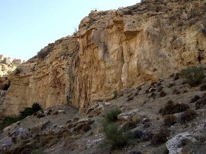 The untouched Aïn Jeddah cliff, up to 40 meters high, just below Ay village, near Kerak.
For Aïn Jeddah
From the Djouma el B’doul sector keep driving, and follow the left branch which goes down.
800 meters of sharp and steep turns bring to a park place next to some old houses.
(16,8 km. from Kerak, by Al Shabhia road – 16 km. from Al Mazar)
Hight: 20 to 40 meters, in a splendid surrounding made of nearly dried up springs (because of upstream catchments in the olive gardens…).
Main orientation – W. The main – and highest – wall is NW facing. Morning shade.
Altitude: 650 m.
GPS: 36R 0751179 / UTM 3449289
Limestone with concretions and tufas.
Has been top-roped quite a lot in 2008 & 2009. NO EQUIPMENT TO DATE.
Do not use bolts, but glue-in rings only, please !
Most of the lines between 6a/b & 7a/b.
The back sector can be reached easier by scrambling down from the top northern edge.
* In that case do not follow the left branch going down, but just keep on driving on the main track under below the crag. Gain the northern edge trough olive gardens and a faint trail.
Style – always steep, sometimes overhanging, beautifully carved with pockets, stalactites, and diverse concretions. Also roofs and bulges !
* Spacious bottom on the main wall only. Otherwise quite exiguous.

Laisser un commentaire