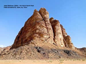
JEBEL UM ISHRIN NORTH PEAKS, WEST SIDE – FROM JEBEL MAKHRAS TO JEBEL UM HAJAJ
En route to Rum village, you pass the Visitor Center and suddenly the view opens over the entire Rum valley. To the left, as the first proud sentinel of Um Ishrin’s range, is Jebel Makhras. This peak bears the gaze of hundreds of incredulous tourists to whom are wrongly designated seven supposed pillars they strive to discern as The Seven Pillars of Wisdom….
ACCESS
On foot from the Visitor Center road – it would be a long walk in the sand… Thus, the 4WD approach especially for Makhras area, is almost mandatory; from Rum village by reversing the arrival road and taking the tracks towards the West flanks of Jebel Um Ishrin, before the Visitor Center. More or less 6 to 7km.
Otherwise from the village, follow the main tracks along the valley to the north, either by 4WD, or walk for 30/45 minutes to the area of Jebel Um Hajaj (routes 175 to 178).
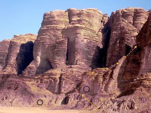
JEBEL MAKHRAS – 1200m
– Finir en Beauté (W)
Y.Astier & M.Kunkler – 1988 – 200m – 9 pitches – 6a – TDinf. Morning shade only.
Apart from poor rock in the first pitches before the 6a crux, the sandstone improves to good, even to excellent in the honeycombed walls, always left of the chimney. Good belays and abseils on slings.
A single set of wires and cams is enough, as the hard passages are short.
4c/4c/3c/5c & 6a/3c/4c/4b/4a/4a
Approach: by 4WD, direct to the base of the face. The start, obvious, traverses from the right, after hiking up the scree.
Descent: abseil down the route on sling stations.
– Bedouin Route from Fara’at al Bel to Mohammed Musa’s Route
Hike, with some delicate scrambling up /or down. Relatively well in shade much of the day for the inner parts.
What’s the purpose? It is the easiest way to enter, or to exit Mohammed Musa’s Route (see next) on his northern end. If you start from the opposite and original south entry (Rum village side), and by choosing this exit, the trip covers a long distance exclusively inside the mountain – from the foot of Jebel Um Ishrin to Siq Makhras.
Consider taking a rope if you are not confident free soloing short, but exposed grade 4 steps. Add few cams and slings.
Access: after entering Siq Makhras, follow the obvious valley to the right (S). This grazing place is called Fara’at al Bel – “Bel” being the most common word for camel in Bedouin dialect.
Rocky features close the valley (*/**). The canyon in the back suggesting a possibility to penetrate the mountain offer good traverse passages on his right side first, not difficult but exposed. After crossing a bushy basin ending on a notch, step up, and traverse on a ledge to the left. Delicate and exposed steps bring down into a chimney, which ends in a canyon bed, and further down to the main stream of Mohammed Musa’s central canyon.
(*) Fara’at al Bel can be reached also from the Wadi Rum side by walking up a steep green wadi to a pass, which gives direct access to the valley. It starts from the left side of the circus mentioned on the next route.
(**) Fara’at al Bel can be reached also from Wadi Um Ishrin side.
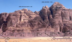
JEBEL UM HAJAJ – NORTH
– Bedouin Route around Um Hajaj mountain to/from Mohammed Musa’s Route.
Scrambling and easy climbing (grade 3 max.) for a very direct access inside the “labyrinthine world” of Um Ishrin mountain. Morning shade for the climb.
Coming from the north, it is located little before Um Hajaj North Tower, when the desert flat forms a circus towards the mountain.
Originally, it is the descent of Mohammed Musa’s Route, as the western explorers did the first time.
But it is also today the fastest access to this route when the goal is to continue down Wadi Um Ishrin side by the “Nabatean Steps”, in Ghôrj Um Ishrin. The height difference to go up, significant, allows you to have almost only descent on the other side… On the other hand, it remains the best return/descent to Wadi Rum when you are coming from Wadi Um Ishrin by As’saoud for instance.
![]()
– West Face Route – Jebel Um Hajaj, North Tower -1350m.
H.Gulfer, W.Haupolter et A.Precht – 20/04/1989 (3h30) – 300m – 11 pitches – V (Precht UIAA grading) – Dsup.
Not much repeated, this nice medium-grade climb on good rock stays in the shade all morning.
Route finding, rather low rating, and descent should not be underestimated.
Approach: obvious, from under below the great arch on the left to the right by terraces bringing to the big chimney which marks the start of the route. Watch out for the leftward traverse.
Descent: abseil down the couloir South of the tower. The long ledge at the bottom brings back to the start. 1h30/2h.
JEBEL UM HAJAJ SOUTH (1450m) AND INNER JEBEL UM ISHRIN MOUNTAIN
– Bedouin Route on the NW gully of Um Hajaj, South summit – to Mohammed Musa’s Route.
As an alternative start – intense scrambling and climbing on a little travelled route, on the shady side of Um Hajaj South summit, and for joining Mohammed Musa’s diverse possibilities.
If the general approach from Dims Hajaj characteristic granite pinnacle is obvious, the route needs accurate route finding to make the junction with Mohammed Musa’s Route.
– Bedouin Mohammed Musa’s Route in the heart of Jebel Um Ishrin mountain
Presents a course of nearly 3 km for 400m cumulated elevation gain – 4a – AD.
The purpose is not a summit at all. It is probably an unprecedented visit for the most successful version of a natural labyrinth, thanks to the extravagance of the local sandstone!
“In fact it is a masterpiece of Bedouin route-finding!….
Named in memory of one of our best friends in Wadi Rum, whose tent used to be in the valley just below Jebel Hajaj, from where he showed us the line of the route many years ago. Mohammed was later tragically killed in a car accident “(Tony Howard in his guidebook, by Cicerone Press UK).
If you look from the village to the base of Jebel Um Ishrin (see photo n° page…. ), there is a clean-cut couloir which separates Jebel Um Hajaj South from the main big mountain. This hidden diagonal couloir takes you not far from the top of Um Hajaj in +/- 2h from the desert floor. Then the itinerary goes up some walls (2/3) before taking you to the root of a canyon (towards north) just after a small desert and slabs. A first junction, not to miss, allows you to go down, without abseil, in the heart of that labyrinth after many others various and fun obstacles. Then, let’s say, they are three main possibilities.
– To cross through on the other side of the mountain (E), down to Wadi Um Ishrin by the “Nabatean Steps” in Ghôrj Um Ishrin. Approx. 6 to 7 hours.
– To come down on the same Wadi Rum side (W), but further north – see inverted route n°175. Approx. 5 to 6 hours.
– Or by Fara’at al Bel if you want to extend the trip as far as possible along inside the mountain to Siq Makhras. Approx. 6 to 7 hours.
See sketch n°….page….
First recorded ascent, and name given by: Sabbah Ataeq, A.Howard & D.Taylor on 08/04/1992 (5h).
You need to be confident in climbing grade 3c/4a without rope, on sometimes exposed passages.
By taking the best itineraries, ropes are not mandatory (but – just in case is more cautious…).
* If the goal is to cross trough to Wadi Um Ishrin by the “Nabatean Steps”, even with the idea of trying to go down without, ropes (25 x 2) are highly recommended, with a handful of cams and few slings.
Approach: for reaching the hidden diagonal couloir which marks the route, drive or walk to the well visible granite pinnacle of Dims Hajaj, one of a kind (not much less than ½ hour walk). Go up the scree behind to reach the starting sort of chimneys. They give access to the diagonal couloir behind, slightly higher than its lowest level.
The route can be reverse any time

Laisser un commentaire